Enregistrez gratuitement cette image
en 800 pixels pour usage maquette
(click droit, Enregistrer l'image sous...)
|
|
Réf : T02939
Thème :
Terre vue de l'espace - Fleuves - Rivières - Lacs (517 images)
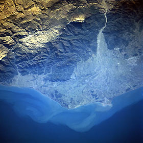
Titre : Safid River Delta, Rasht, Iran November 1995
Description : (La description de cette image n'existe qu'en anglais)
The deltaic plain of the Safid River can be seen in this near-nadir view. The rugged, forested Elburz Mountains cover the upper and upper right portion of the image. The Caspian Sea is visible covering the bottom third of the image. The Safid River, 450 miles (725 km) long, rises in the Tallish Mountains of northwestern Iran and flows generally eastward, emptying into the Caspian Sea near the city of Rasht. The river has cut a water gap through the Elburz Mountains (upper right), and this gap provides a major transportation route between the capital city of Tehran (not visible on the image) and the Caspian lowlands. At the right center of the image, the city of Rasht, a major silk-manufacturing center, is discernible. Rasht is a trade center for an agricultural region where rice, cotton products, and peanuts are produced.
|
|

